
")
UNDET is a simple yet powerful Extension to produce accurate 2D, 3D & BIM deliverables based on point clouds (3D scan data).
It seamlessly integrates into SketchUp or Revit, taking advantage of well-thought-out point clouds features and tools. This cuts down the learning curve and increases efficiency when working with 3D scan data.
Windows 10 - 64 Bit *
SketchUp 2019 and later
16 GB RAM **
Video card 4+ GB 100% OpenGL ***
* macOS not available
** For heavy-duty point cloud data, 32 GB or more is recommended
*** If you are looking for a new system or upgrade, please pay extra attention to the video card. We do recommend video cards with a nVidia RTX chip. These cards support OpenGL very well and have qualitative drivers. OpenGL is the heart of the 3D view. On-board video cards (soldered chipsets) are strongly discouraged!
Pricing Undet
Please contact your reseller for buying Undet.
All mentioned prices are excl. VAT and per license / activation!
| Commercal licenses Undet for... | ...SketchUp | ...Revit |
|
Monthly License |
€ 89,- |
€ 209,- |
| Educational licenties | ||
|
Student - 3 Months (request directly) Classroom - 10 Seats - 1 year |
€ 0,- € 1500,- |
€ 0,- € 1500,- |
Efficient
Be productive and efficient working with massive point clouds and save valuable hours on as-built 2D and 3D documentation work. With UNDET you can accelerate the as-built modelling process by 2-3x, significantly reducing project timelines.
Powerful
Point clouds store extremely detailed information and it can become unmanageable. UNDET accelerates the workflow even when working with huge point cloud data sets.
Error Prevention
Preventing reworks and errors is more effective than spending time and resources fixing problems after they occur.
Easy to Learn
The shorter the learning curve, the sooner you can get the benefits.
Undet for SketchUp - Overview
Features
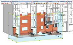
Point cloud clipping box
Point cloud clipping, slicing and cropping tools to control the point cloud information you see in your model view.
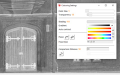
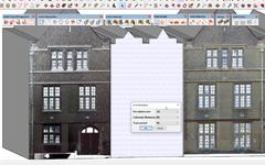
Point cloud visualization
Point cloud visualization & advanced colouring management tools to rapidly see the finest details of point clouds.
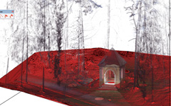
Ground surface meshing
Surface meshing tools, to extract the ground surface level from unclassified point cloud data, by eliminating real-world objects (trees, cars, noise, poles…).
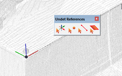
Snapping and reference
Snapping and reference tools to set up the axis to point cloud view, place points, or reference line objects.
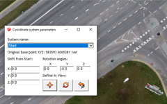
Georeferenced data support
Georeferencing tools to import point cloud files in-state / large coordinates system. Rotate & Move the point cloud to the axis or existing model.
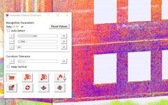
Auto feature extraction
Auto feature extraction tools to achieve maximum accuracy of extracting/extruding/fitting the plane to point cloud points.
Texturing & orthophoto
Texturing tools to apply the point cloud rendered view to the selected plane.
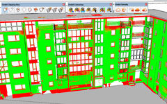
3D Model inspection tools
Inspection tools to compare your 3D model to the point cloud to check accuracy.
UNDET vs. Trimble Scan Essentials
UNDET
€500 /Year
- Commercial license sold separately
- Free trial available (5 days)
- Educational licenses available (with a discount)
- SketchUp Integration
- Native SketchUp Tools
- LayOut Integration
- Project creation
- Project creation from registered point cloud files
- Scan station files grouping (inside / outside scans)
- *.E57 (vendor-neutral format)
- *.LAS (remote sensing ASPRS)
- Trimble RealWorks projects (paid software)
- *.FLS, *.FPR, *.LSPROJ (FARO)
- *RCP (Autodesk Recap)
- *.PTX, *.PTS (LEICA)
- *.ZFS (Z+F)
- *.CL3, *.CLR (TOPCON)
- *.RSP (RIEGL)
- *.LAZ (LiDAR)
- *.DP (DOT Product)
- *.PLY (iPhone, iPad)
- Custom ASCII / TXT / XYZ file format import
- Point Cloud visualization & coloring
- Source (RGB)
- Intensity
- Plane
- By Z
- Greyscale
- Inspection Tools
- Transparency / blending settings
- Auto contrast coloring tool to get best view
- Advanced coloring setting (point size, shading schemes)
- Point Cloud visibility and clipping box views
- Hide / Show point cloud points
- Point Cloud Density settings
- Advanced density settings adjustment to PC hardware performance
- Visibility management for groups or for each point cloud data file
- Independent point cloud clipping box
- Independent point cloud clipping box resize, move, rotate tools
- Point Cloud and model clipping with SECTION PLANE tool
- Point Cloud clipping box view creation by picked point cloud point
- Point Cloud clipping box view creation by selected SketchUp object
- Point Cloud clipping box view creation by line
- Point Cloud clipping box view creation by rectangle
- Point Cloud clipping box view save to scene tool
- Texturing and orthophoto creation tools
- Apply texture to selected plane from visible points
- Apply texture to selected plane from full resolution points
- Apply texture to large plane to generate orthophoto
- Apply texture to ground surface mesh
- Snapping and reference tools
- Georeferenced data support (coordinate system manager)
- Guide Lines & Points
- Snapping to Point Cloud point using SketchUp tools
- Smart snapping tools to detect vertical, horizontal orientation
- Axis creation by snapping to Point Cloud point
- Auto feature extraction
- Automatically find best fitting plane
- Automatically fit selected plane or entity to Point Cloud points
- Extrude plane to Point Cloud points
- Find corner line
- Extract ground surface mesh
- Undet Browser Integration
- Free point cloud viewer
- Feature to open a 360-degree scan view on selected scan station
- Automatically find the nearest scan positions to straighten the 360 panoramic view.
- Translate view section by clicking on any spot
- Draw points to SketchUp model space
Scan Essentials
€689 /year
- Included in the SketchUp Studio Subscription bundle
- Free trial available (30 days)
- Educational licences available
- SketchUp Integration
- Native SketchUp Tools
- LayOut Integration
- Projectcreation
- Project creation from registered point cloud files
- Scan station files grouping (inside / outside scans)
- *.E57 (vendor-neutral format)
- *.LAS (remote sensing ASPRS)
- Trimble RealWorks projecten (betaalde software)
- *.FLS, *.FPR, *.LSPROJ (FARO)
- *RCP (Autodesk Recap)
- *.PTX, *.PTS (LEICA)
- *.ZFS (Z+F)
- *.CL3, *.CLR (TOPCON)
- *.RSP (RIEGL)
- *.LAZ (LiDAR)
- *.DP (DOT Product)
- *.PLY (iPhone, iPad)
- Custom ASCII / TXT / XYZ file format import
- Point Cloud visualization & coloring
- Source (RGB)
- Intensity
- Plane
- By Z
- Greyscale
- Inspection Tools
- Transparency / blending settings
- Auto contrast coloring tool to get best view
- Advanced coloring setting (point size, shading schemes)
- Point Cloud visibility and clipping box views
- Hide / Show point cloud points
- Point Cloud Density settings
- Advanced density settings adjustment to PC hardware performance
- Visibility management for groups or for each point cloud data file
- Independent point cloud clipping box
- Independent point cloud clipping box resize, move, rotate tools
- Point Cloud and model clipping with SECTION PLANE tool
- Point Cloud clipping box view creation by picked point cloud point
- Point Cloud clipping box view creation by selected SketchUp object
- Point Cloud clipping box view creation by line
- Point Cloud clipping box view creation by rectangle
- Point Cloud clipping box view save to scene tool
- Texturing and orthophoto creation tools
- Apply texture to selected plane from visible points
- Apply texture to selected plane from full resolution points
- Apply texture to large plane to generate orthophoto
- Apply texture to ground surface mesh
- Snapping and reference tools
- Georeferenced data support (coordinate system manager)
- Guide Lines & Points
- Snapping to Point Cloud point using SketchUp tools
- Smart snapping tools to detect vertical, horizontal orientation
- Axis creation by snapping to Point Cloud point
- Auto feature extraction
- Automatically find best fitting plane
- Automatically fit selected plane or entity to Point Cloud points
- Extrude plane to Point Cloud points
- Find corner line
- Extract ground surface mesh
- Undet Browser Integration
- Free point cloud viewer
- Feature to open a 360-degree scan view on selected scan station
- Automatically find the nearest scan positions to straighten the 360 panoramic view.
- Translate view section by clicking on any spot
- Draw points to SketchUp model space